Viet Nam wetlands: selected case studies
Location: Hanoi, Viet Nam . 2nd Oct 2012
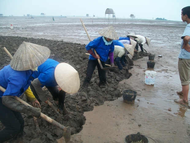
1. Xuan Thuy National Park: Benefit sharing agreement
Established in 1989, Xuan Thuy National Park was the first Ramsar site in Southeast Asia (and the fiftieth worldwide). It contains some of the last remnants of the coastal ecosystems of the Red River Delta and is internationally significant as a migratory bird habitat, notably for the globally threatened Black-faced Spoonbill. The park is also of high economic importance: thousands of shrimp farmers, clam seed producers, and clam collectors depend on its mangroves and mud flats. Since its designation as a Ramsar site, the demand for natural resources has led to the almost complete conversion of the park to shrimp production. While the area under mangroves has recovered as a result of mangrove replanting on new mud flats, the park’s core zone remains a de facto open access area. The park’s management board can neither officially accept the presence of people in the core zone, nor can it strictly follow national laws that forbid human use of the core zone. In an effort to defuse competition and conflict over these resources, the management board has piloted a benefit sharing agreement for households involved in highly profitable clam seed production. The other signatories are the local government and management board. According to the park’s analysis, the agreement has generated significant revenue to support local welfare services but has failed to address over-harvesting of clam seed.
2. Lap An Lagoon: Mangroves threatened by golf course
Lap An Lagoon is located in Thua-Thien-Hue Province. Over the last 20 years the area of mangroves has shrunk from 100 hectares to just five hectares of poor quality mangrove as a result of conversion to aquaculture and infrastructure development. This last patch of mangroves is now threatened by clearance for a golf course. With MFF support, the Center for Community Research and Development (CCRD) is working to protect the lagoon’s remaining mangroves bearing in mind the results from micro-tidal estuaries and lagoons in Sri Lanka that emphasise the importance of mangrove conservation and natural regeneration rather than mangrove replanting. In February 2012, the national newspaper Nong Thon Ngay Nay (Agriculture Today) published a story on the proposed golf course; in March, the case was discussed at an MFF training course for environmental journalists; and in April, the Deputy Prime Minister sent a letter to the provincial government instructing them not to convert the mangrove protection forest. For now, Lap An Lagoon’s remaining mangroves seem safe but to make sure CCRD is surveying the mangroves as a first step in getting them legally protected.
3. Mekong Delta: High costs of intensive rice production
Over the last 10 years the construction of high dykes in the Mekong Delta to allow a third, or autumn-winter, rice crop to be grown has blocked the annual replenishment of freshwater, nutrients, and sediment on which fish depend. In turn, this has destroyed the wild fisheries on which the landless, who make up 20% of the Mekong Delta’s population, depend. The high dykes have also greatly reduced the annual flushing, which has resulted in the accumulation of pathogens and toxins in the surface water and growing public health problems. In hydrological terms, high dykes have separated the Mekong River from its 1.5 million-hectare floodplain. They have narrowed the floodplain during the peak October-November flood from 150 kilometers to a few tens of kilometers. This has accelerated the water flow and displaced flooding to urban and industrial areas downstream. Reduction of the flooded area has also reduced groundwater recharge, reduced river base flows, and increased dry season saline intrusion, which increases the cost of drinking water supplies. The violent floods of 2011 call into question the value of the third rice crop and instead argue for a more natural hydrology that provides multiple benefits, including greater resilience to climate change, which is likely to result in more intense rainfalls and flash flooding.
4. Ha Tien Plain: Large scale wetland conversion
While most of Vietnam’s limestone is in the north, most of the cement demand is in the south. In response, the Kien Giang provincial government has licensed several state owned enterprises and on international company, Holcim Vietnam Limited (HVL), to mine the area’s karst hills to produce cement. This has resulted in the complete destruction of several hills and extensive damage to others. Even on intact hills, no pristine vegetation is left as a result of fuelwood collection and chemical defoliant during the American War. IUCN is cooperating with HVL to compensate for the unavoidable impacts of its operations by supporting the establishment of two nature reserves as biodiversity offsets. One nature reserve will protect the remaining intact karst hills that are one of the richest sites in the tropics for soil invertebrates. The first endemic arthropod was described in 1995. Since then many species new to science have been discovered, revealing the area to be of overwhelming biological interest. The other nature reserve will protect the remaining area of natural grassland in Phu My, next to the border with Cambodia. This area is important as roosting habitat for the Sarus crane, which visits every March-April at the end of the dry season. However, the Phu My grassland is highly threatened by conversion to rice and shrimp farms.

Clams collection by local women at Xuan Thuy National Park , Xuan Thuy National Park © Xuan Thuy National Park
Related Images
Related Documents